Navigating with Topographic Maps
The Outdoor Smorgasbord 08.06.12
I’ve heard people say that there is no excuse to get lost if you have a decent set of topographic maps in hand. While that is mostly true, there are a few things you can do to greatly improve the readability and reliability of your map.
If your projected route from point A to point B is a series of turns and twisted through contour lines, you must have confidence that at every point along the way you are still on the right track. Wouldn’t it be nice to have confirmatory landmarks spaced out along the way to reassure you that the perceived truth is actual truth?
The best way I’ve found to do this is to draw in some features that topo maps don’t necessarily emphasize but that can be easily seen when accessing online maps of other types – aerial maps being the best resource. Features such as rock faces, avalanche chutes, and uniquely shaped meadows don’t always show up well on topo maps but can provide a reassuring boost of confidence that you on the right trail in the backcountry.
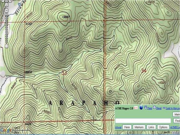
Here’s an example of a topo map from central Colorado with a bunch of potentially confusing contour lines.

It shows that outside the open terrain on the far left and far right sides of the map, everything else is timbered and without any dramatic terrain features could potentially be confusing for some hikers or hunters. Switching to an aerial map of that exact landscape (all I did was switch from topo to satellite view on an online mapping resource, ACME Mapper), you can see that the topo map was missing some valuable information.

You can see that there is an easily distinguishable meadow oriented north to south in the middle of the satellite image and a larger complex of meadows in the northeast quadrant of the same topo map that showed a monoculture of timbered country. The topo map also doesn’t highlight any of the transitions from deciduous (leaf on in the summer, off in the winter) to coniferous tree cover – another potentially useful feature that can only be drawn from an aerial map. I highly recommend overlaying your topo maps with an aerial image resource and penning in some features that will surely make your hunt go a little smoother this fall.

I’m 28 years old and I am currently stationed at Auburn University where I am pursuing a doctorate degree in wildlife sciences. Before this stage of life, I spent the better half of my life living in Alamance County, North Carolina. I’m convinced that my father’s love for deer hunting fostered a permanent infatuation with the outdoors in my life. As a 12-year old, I killed my first deer at my grandpa’s farm in northwestern PA. From the time that bolt-action .243 barked in 1996, it was a slippery slope towards obsessive addiction. My passion is white-tailed deer hunting, especially with archery equipment.
However, as my blog name would suggest – I don’t consider myself a one dimensional outdoorsman. I am just as likely to be wading shallow lake waters trying to arrow prehistoric bowfin and torpedo-shaped grass carp, busting the January brush for cottontails, combing hillsides for antler sheds, calling ducks in a timbered swamp, battling monster flathead catfish, or setting traps for beavers and raccoons. My passion also takes me outside NC boundaries – bowhunting elk in Montana’s Bitterroot Valley, glassing pronghorn in Wyoming’s plains country, stalking mulies at the base of the Bighorn Mountains, waiting for a Kansas whitetail to funnel past a treestand. The list could go on.
I guess the thing that makes me somewhat unique is that I have taken my love for the outdoors and genuinely made it my life’s pursuit. I received a 4 year degree in wildlife sciences from North Carolina State University in December 2006. Since then, I’ve also completed a master’s degree that focused on using GPS collars to examine how adult bucks react to hunting pressure at Chesapeake Farms, Maryland.
My current project at Auburn University also uses GPS technology but my objectives are different. I am looking at breeding strategies by different age class bucks in a very unique, high-fenced deer population. I also intend to address the controversial issue of fair chase, as well as spearhead numerous side projects while at the University.
Well, enough about me, my wife is extraordinarily beautiful if I do say so myself. We were high school sweethearts and were married in January 2008 and were joined in September 2011 by our beautiful daughter Raelyn Mae.
Finally, what can you expect from my blog. I will bring you many exciting experiences, practical how-to tips, and candid product reviews, but I also want to bring you a unique perspective from the science behind the great outdoors.
