Preparing for a Managed Deer Bowhunt
In Search of Whitetails 12.12.12
This year I drew a slot in a managed deer hunt in Missouri, a bowhunt in a suburban conservation area that’s just stupid with deer. Managed hunts are super-competitive in Missouri. Every hunter gets to apply for just one per season, and the drawing odds for the most desirable hunts are less than 5%. So yeah, I feel a little bit like I won the lottery. The only problem is that getting drawn is the easy part. Having a successful managed hunt is much harder.
Hunting Unfamiliar Terrain
My managed deer hunt begins this weekend in an 8400-acre tract of (mostly) woodland bounded by two major highways and a river. It’s a huge area. There are at least 5 parking lots and several hiking trails that spiderweb the area. And I know there’s a lot of deer there, in part because there’s another conservation area (7,000 acres) just across the highway, in part because I and others have seen whole herds of deer browsing in the open along the highway. There’s a high school nearby, and the land is popular for hikers and squirrel hunters. So the deer are accustomed to human activity. That’s the good news.
The bad news is that I’ve never hunted there before. I haven’t even scouted the area. Until I can get boots on the ground this Friday, I’ve been doing some preliminary research. This might be useful to other hunters, the kind of “digital scouting” that can be done when you can’t get afield.
Records of Previous Managed Hunts
God bless the Missouri Department of Conservation for keeping excellent records and making those publicly available. The results of managed hunts from previous years give me some information about what to expect.
| Year | Slots | Drawing Odds | Actual Hunters | Bucks | Button Bucks | Does | Total | Success |
| 2010 | 300 | 67% | 203 | 3 | 4 | 15 | 22 | 10% |
| 2011 | 300 | 61% | 193 | 6 | 3 | 16 | 25 | 12% |
You can see that I entered for a hunt where I had a good chance of getting drawn (about 2/3). The odds are better because it’s late season and there are many slots, but hey, I’d rather have this managed hunt than no managed hunt at all. And the good news is that 1/3 of the hunters drawn never went, so I don’t have to worry about them. That leaves 200 other hunters, still a crowd but with the size of the area it’s still over 40 acres per hunter. Generally speaking, about 1 in 10 hunters takes a deer from this particular managed hunt, and over 80% of those deer don’t have antlers.
Lesson: I’m far more likely to take a doe. If I have a chance at one, I should take it.
Asking the Deer Hunting Community for Help
First things first, I got on my favorite bowhunting forum over at Missouri Whitetails and asked other hunters for advice. The bowhunting community has always been helpful, almost surprisingly so. So many other hunters have been willing to share their scouting reports and hunting experiences, even for open public land where they might be actively hunting this season. I think most of us realize that helping one another out (to a large extent) won’t impact our own hunting opportunities. Most of the time, there’s plenty of woods and plenty of game, and when one bowhunter takes a nice deer, that’s a win for all of us.
The ever-helpful MWT community had some good intel on the managed hunt. Some excerpts:
“I’ve been there a time or two. There are lots of deer, and like everywhere on public ground, the further from parking lots you get, the less hunters you will see.”
“Last year I took a nice old 8 pt down by the quarry site. This year I basically had to kick people out of my stands every time I went out, then they would make as much noise as possible getting out. I saw a lot of Does and fawns and one large buck… They were all running or spooked by something else by the time I saw them though.”
“The entire place is covered with deer. Hard to to find a bad spot on the place. The deer are very use to people and they get kicked up all the time. Find either a good food source or a nice funnel and the deer will come.”
“You’re pretty much spot on, the deer are used to seeing people out there. The food source part might be tougher this year. Hardly any of the corn out there made anything. There are a few winter wheat plots around the area though.”
“All the parking lots are used and although there seems to be alot of deer they can be very tough to get in range.”
From more than a dozen replies and some follow-up conversations by IM, I’ve drawn some preliminary conclusions about this hunt:
- There are lots of deer, and they’re used to people.
- There will be lots of hunters, and some don’t respect personal property (like tree stands). Getting away from the crowd, as I usually do when stand hunting on public land, will be key.
- While some obvious food plots might be active, they’re likely to be heavily hunted.
- Given the hunting pressure and crowd and other human activities, it seems that the best strategy will be to find a remote place where deer are likely to travel through or hole up in response.
Scouting with Google Maps
One of the most important tools I use for planning and reviewing hunts is Google Maps, or more specifically the copy of Google Earth that I downloaded to my laptop. This let me add some custom layers, including statewide conservation areas, additional satellite imagery, and topographic maps. I can mark features on the map and pull up waypoints that I marked on my GPS while in the field. It’s powerful, powerful stuff.
To demonstrate, I’ve zoomed in to an area in the middle of the conservation area, about 1 mile square or 640 acres.
Google Satellite Map of Hunting Area
Here’s the Google Satellite view with imagery from August 2012 (4 months old at the time of writing):

I’ve annotated some points of interest: water sources (2 ponds and a spring), a possible funnel between two agricultural fields, and a parking lot. This last one is important, because parking in one of the 5-6 designated lots is required for the hunt. Some observations:
There’s a nice foot trail from the parking lot that provides access to much of the area.
Most of the obvious food plots are near the parking lot, so they’ll probably be heavily hunted.
Different shading in the forested areas suggests some uneven terrain.
USGS Satellite Map of Hunting Area
One of the layers I’ve added to Google Earth is old USGS satellite imagery. It’s in black and white, which is a bummer, but appears to have been taken in winter or early spring, so I think it gets better resolution of the land beneath the trees.

I know this is older imagery because the ponds aren’t there when it was taken. The agricultural fields have shrunk a little bit. Perhaps most importantly, there are clusters of dark flecks that I suspect indicate evergreens. Transition areas between these spots and the surrounding hardwoods are good potential hunting spots.
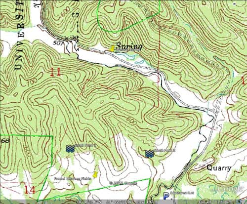
USGS Topo Map of Hunting Area
Probably the most powerful thing about Google Earth is the USGS 1-meter topographic map layer that I’ve added. It was tricky to find a layer that worked, but once I did, I got access to fairly accurate topographic maps of the places I hunt. For this example area in particular, the topographic map is hugely informative:
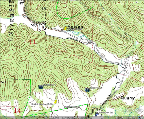
Now we have some precise details on the geography — the ridges are at least 100 feet above the parking lot. And just north of the midpoint between the two small ponds there’s a saddle between ridges, another great ambush point. I’ve marked these and some other candidate spots for scouting before the hunt begins. I’ll report back, hopefully with some photos.

