Bank Access, Parking Area Now Available at Kentucky’s Long Bar Area

Trout anglers on Cumberland River now have public bank side access to the Long Bar area in Clinton County.
“This is one of the better fishing areas on the entire river for trout,” noted Dave Dreves, fisheries research biologist for the Kentucky Department of Fish and Wildlife Resources.
The Long Bar Fishing Access property, which is owned by Kentucky Fish and Wildlife, consists of a 12-acre island and four adjacent acres on the bank. While the area opened to the public in 2009, the only way to access it previously was by boat.
Kentucky Fish and Wildlife recently completed a 15-vehicle parking lot for the area, which some locals refer to as Snow Island. Work to open land-based access to the location included construction of an access road and fencing to keep cattle in adjoining pasture land.
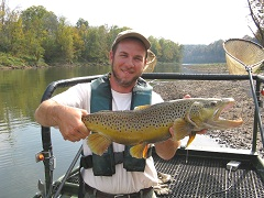
 Dreves noted the area adjacent to the island is a highly productive place to wade fish for rainbow, brown and brook trout. Wading anglers must cross a small side channel in order to reach the main channel adjacent to the island.
“Anglers need to be aware of river levels,” explained Dreves. “At low water, there is a gravel bar with knee-high water over it that anglers can use to wade over to the island.”
If anglers aren’t paying attention, however, they may not notice the river rising and may have to navigate back to the bank in chest-high water, or possibly have to swim back.
The Cumberland River’s level is controlled by Wolf Creek Dam at Lake Cumberland, located approximately 10 miles upstream of the Long Bar Access. Releases from this hydro-electric dam can make the river fluctuate as much as 15 feet at the access area. The current during times of electrical generation at the dam is strong.
The Nashville District of the U.S. Army Corps of Engineers, which operates Wolf Creek Dam, posts its projected generation schedule for the following day online at www.orn.usace.army.mil/. Anglers may also call the local U.S. Army Corps of Engineers’ fishing information line at (606) 678-8697. A recorded message informs anglers of projected water generation schedules for the day and fishing information about Lake Cumberland.
To get to the Long Bar Fishing Access from Jamestown, take U.S. 127 across Wolf Creek Dam. Turn right onto KY 1730 and follow it until the road ends at Swan Pond Road; turn left. This road becomes Wells Bottom Road; bear right at the road fork with Desda-Wells Bottom Road. Look for the new access road and the Long Bar Fishing Access sign to the right.
From Albany, travel north on U.S. 127; turn left onto KY 3063 (Desda-Wells Bottom Road). Bear left at the fork in the road onto Wells Bottom Road to the fishing access located on the right.
GPS coordinates for this site are 36.8847, -85.2244.

