Google Fishing Map Points to NW Oregon Trout Locales
OutdoorHub 03.21.12
The Oregon Department of Fish and Wildlife today introduced a new Fishing Map to help anglers find trout stocking locations in the department’s Northwest Region.
The Google-based map is available via the ODFW website and details 111 sites around the Willamette Valley and North Coast areas of Oregon where the department releases more than 1.2 million hatchery-reared rainbow trout. ODFW releases rainbow trout ranging in size from “legals” about eight inches long to “trophies” that can weigh in excess of 10 pounds. The planters are produced by several ODFW trout hatcheries. Trout stocking is one of ODFW’s largest and most popular recreational programs.
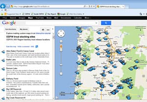
The fishing map can be accessed from the department’s website from links in several places, including the Trout Stocking Schedule page, weekly Recreation Report and Where and How to Fish page. The map allows viewers to zoom in for a close-up at the sites in their choice of map, satellite and terrain view. Clicking on the icon opens a text balloon with site photos, links to nearby campgrounds and other points of interest, fish species, and links to ODFW’s weekly recreation report, trout stocking schedule and sport fishing regulations. The Google engine is also capable of generating GPS coordinates and directions from any starting point. Sites are designated with blue icons that look like a fish head and hook and line.
Trout fishing is the most popular fishery in the state, according to a survey of anglers the department conducted in 2006, and the new fishing map is designed to build upon that popularity. Of those anglers surveyed in the 2006 study, 73 percent said they had fished for trout in the past year. That equates to approximately 420,000 anglers.
“This is our most popular fishery, and the trout we produce at our hatcheries are a very important component of trout fishing,” said Rhine Messmer, ODFW Recreational Fisheries Program manager for Inland Fisheries. “A lot of the time these fisheries provide entry-level opportunity for our younger anglers and their families at ponds, lakes and streams across the state. These fisheries are by nature some of the easiest to participate in and are important to angler recruitment.”
Because it is so heavily populated, ODFW releases a large share of its hatchery-reared trout within the department’s NW Region, which is the most populous area of the state and spans 13 counties, including Benton, Clackamas, Clatsop, Columbia, Lane, Lincoln, Linn, Marion, Multnomah, Polk, Tillamook, Washington, and Yamhill. The cost of the trout stocking program is covered primarily through the sale of Oregon fishing licenses.
Freshwater fishing is a huge economic driver for Oregon. A 2009 study for the department by Dean Runyan and Associates estimated that the freshwater fishing contributed nearly $200 million to the state’s economy every year. While the study didn’t break sales down by fresh water species, which would also include salmon, steelhead and other types of fish, the economic impact of trout fishing on the state’s economy is nonetheless significant.
“Given the high level of participation there is no question this is a high value fishery,” said Messmer.
The fishing map is the latest addition to a suite of Google-based maps, including the Wildlife Viewing Map and Oregon Hunting Map.

