‘HUNT New York for Garmin’ Now Available from Hunting GPS Maps
OutdoorHub 09.13.13
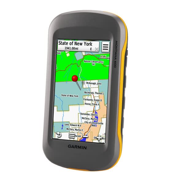
With “HUNT New York for Garmin,” you’ll always know your precise location and which person or agency owns the land, whether you’re hunting privately owned farmlands or publicly owned forests and marshes – almost anywhere in the Empire State.
This essential hunting tool from Hunting GPS Maps of Missoula, Montana, features fast-loading, 24K topographical maps for your handheld GPS units. These 20-foot-contour topos also feature a color-coded layer that highlights public property within the entire state, and includes county, state, and federal lands. These maps have also included PLAT data which shows the land owners’ names and farm boundaries in 49 of New York’s 62 counties.
In addition, HUNT New York Premium maps identify all roads, trails, topographical information, wildlife management units (WMUs), and much more. In fact, these digital maps don’t include legends because all necessary information appears on the map.
This innovative electronic mapping system is endorsed by several state and federal agencies because it’s the most reliable source of all land-ownership maps on the market. Hunting GPS Maps updates ownership information annually by combining data from 15 different sources into these information-packed topographic maps.
This electronic information is stored on Micro SD cards that insert into Garmin GPS units. Hunters can also plug the card into their computers and access the information to study the terrain, plan routes and mark waypoints with Garmin’s free BaseCamp software.
Hunting GPS Maps allow hunters to:
- Discover little-known, seldom-used public lands across New York;
- Determine public-land type, including DEC Wildlife Management Areas, state forests and parks, forest preserves, county and municipal property, national forests, National Park Service, U.S. Fish and Wildlife Service, U.S. Army Corps of Engineers, or other agencies;
- View plat data, private-property boundaries and landowner names so you can request permission for access;
- Navigate around private lands closed to hunting;
- Identify deer-wildlife management unit boundaries; section lines/numbers; highways, roads and trails; as well as lakes, rivers, streams, creeks and springs.
Hunting GPS Maps are easy to use. Just insert the Micro SD Chip into the slot in your Garmin GPS and go. You don’t need to download software or do any fine-tuning with a computer. Just plug and play! With the GPS unit’s capabilities for zooming and layering, Hunting GPS Maps fills each map with useful names and property information, yet keeps the display clean and organized.
Hunting GPS Maps are available for all Western states, including Alaska; also maps for Pennsylvania, Wisconsin, Ohio, Michigan, Minnesota and Indiana. More Hunting GPS Maps will arrive soon for other Midwestern and Eastern states. Never again must you buy or carry clumsy paper maps and county plat books.
For more information on Hunting GPS Maps, please contact Matt Seidel at 208-GPS-MAPS or visit www.HuntingGPSMaps.com.

