Manage Your Hunting Land with the Tip of a Finger with HuntStand
Derrek Sigler 09.25.14
I really enjoy incorporating technological advancements with outdoor pursuits like hunting. I frequently try to “disconnect,” but I keep getting pulled back in. One such tech tool that I’ve been enjoying is the new HuntStand Lite app for smartphones and tablets from the folks at TerraStride.
What’s in the box?
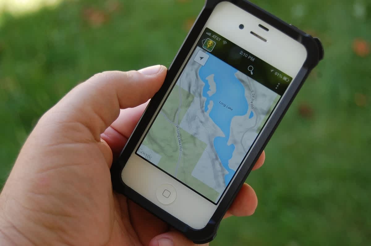
The app uses GPS data, along with sophisticated mapping programs, weather data, and satellite images to create an interactive overlay of your property. I’ve seen programs that let you use those tools before, but not in a single app, and not from my iPhone. When I first saw the specs, I thought that the app would be useful for someone with a huge chunk of land to manage, but wasn’t sure it’d work for those of us with a smaller parcel. Boy, was I wrong!
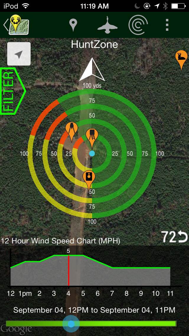
So what all does it do? Let me start out with my favorite part of the app. Normally I’d try to build up to this a bit more, but this is pretty good. You can mark your stand or blind location on the interactive map of your hunting land. Then you can get weather data for that location and the app will show you how the wind will affect your scent dispersion for a given spot. If you’re like me, and you play the wind, knowing how your scent will disperse into your hunting area can be just the ticket for knowing which stand to hunt from on a given day.
And now for the Action Team Weather Center
I sound like a cheesy local even news anchor, but there’s a lot more to this app. The wind direction tool also works for those of us who hunt waterfowl. Want to hunt geese and set your spread the right way to be in the zone, but the wind is still in the morning hours before sunrise? The HuntStand app will show you the projected landing areas for a set location! Lanford Holloway, CEO of TerraStride, said there is another feature that is unique to the HuntStand app’s weather functionality.
“The biggest difference of this app over other apps that are similar is that the HuntStand Lite app continues to work in areas not served by data,” Holloway said. “We consider the weather data for a given area to be good for about a five-mile radius. The app downloads the five-day and 72-hour forecast, so if there is no data to live-update the app, the app will work off of the weather data it has already loaded. This way, all of the features of the app will work in areas not served by live data.”
I tried using the app in the mountains of Utah on a recent trip. There was no data signal, but I still had a pretty accurate picture of the weather systems and had a pretty good idea of what was going on. This was during the torrential rainfall that flooded areas of Arizona, Nevada, and Utah, and washed-out roads and highways. The weather tool proved accurate in showing when different storm fronts were moving in, even though there was no data signal in some of the areas I was in.
There’s more
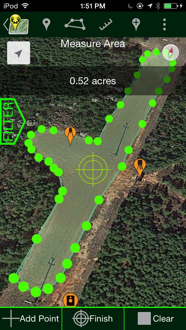
The app also allows you to measure off a given area, like a food plot. The area measurement tool is extremely popular, Holloway said. It allows you to accurately map and measure a section of property. It works well for food plots, or even to survey a piece of property, using satellite images and GPS.
“We used this tool to measure a football field and were accurate to within two-hundredths of an acre,” Holloway said. “It’s very helpful when figuring out things like how much fertilizer you need to measure out for the size of your food plot.”
There is also a distance measurement tool. An outfitter with a big piece of property can use the app to map out stand locations and routes for hunters to take to reach the stands and then share that information with the hunter before a morning hunt. I’ve been on outfitted hunts where I’m stumbling around in the dark trying to find reflective dots on trees on my way to my stand. This app would make that so much easier and less stressful.
The app has 43 customizable marker icons that users can drop in on their maps. Users can change the titles of the icons for use as notes, or to make things easier to identify. It also allows for the user to add notes, so you can make observations when you see things, and then mark it and notate what was special about that marker.
HuntStand was a very popular app last year and the improvements only seem to expand on that and make it even more usable.
“It was our most downloaded app,” Holloway said. “It was one of the most popular hunting apps last year. We’re expecting similar results with the upgraded version and even more from HuntStand Pro, which will launch later.”
A more robust version of the app, HuntStand Pro offers more features and will be available shortly. The HuntStand Pro version will be available shortly. HuntStand Lite is available for both Android and Apple devices.
It’s rare that I get excited over an app, but I am really digging this one. It packs several things I find myself using to manage my hunting land into one program and the weather and wind direction tools are extremely helpful. As someone who switches from field hunting geese to bowhunting for deer in the same day, I have found the information to be invaluable in planning my hunts.
Note added 9-26-2014: This article has been updated to correct factual information about HuntStand Pro.

